The village of Moose Creek is located approximately 80 km southeast of Ottawa in the North Stormont Township. The Moose Creek drinking water system is owned by the Township of North Stormont and operated by the Ontario Clean Water Agency (OCWA). The well field contains 3 wells and serves a population of approximately 300 residents.
Vulnerability Scoring
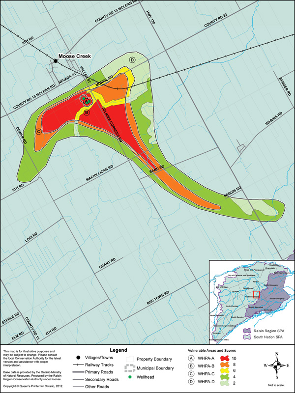
Four Wellhead Protection Areas (WHPAs) have been delineated representing differnt times of travel to the well: WHPA-A, WHPA-B, WHPA-C and WHPA-D (travel times of "immediate", 2 years, 5 years and 25 years respectively). The WHPAs have been scored from 2 to 10. The vulnerability score is a representative measure of the drinking water source's susceptibility to contamination. Higher scores indicate higher vulnerability.
| Vulnerable Area |
Land Area by Vulnerability Score (ha)
|
||||
|---|---|---|---|---|---|
|
10
|
8
|
6
|
4
|
2
|
|
| WHPA-A | 7.2 | - | - | - | - |
| WHPA-B | 178.7 | 44.5 | 26.2 | - | - |
| WHPA-C | - | 129.2 | 23.3 | - | 2.9 |
| WHPA-D | - | - | 0 | 405.4 | 146.9 |
Source Protection Policies
The following activities if occurring in a vulnerable area near the drinking water source could be a significant drinking water threat*:
- Waste Disposal Sites
- Sewage Works
- Agricultural Activities
- Pesticides
- Salt and Snow
- Fuel
- Chemicals
* Please consult the Source Protection Authority or the Risk Management Official to determine the exact circumstances, and locations where source protection policies apply near this drinking water source.